A Lunar
Foundation Model
Lunar-FM is humanity’s first AI foundation model of the Moon

The Frontier Development Lab (FDL.ai) LunarLab, a partnership between the Luxembourg Space Agency (LSA), the European Space Resources Innovation Centre (ESRIC), and Trillium Technologies, today announced Lunar-FM, the first AI foundation model dedicated to lunar exploration and resource prospecting.
Developed with compute and technical support from Google Cloud, NVIDIA, SCAN Computers International Ltd, and Datarock, Lunar-FM represents a novel application of self-supervised Artificial Intelligence designed to address the data fragmentation and heterogeneity inherent in current lunar remote sensing.

Addressing Data Heterogeneity in Lunar Science
Scientific data regarding the Moon is currently siloed across disparate archives and instrument types, ranging from optical imagery and thermal radiometry to gravity anomalies.
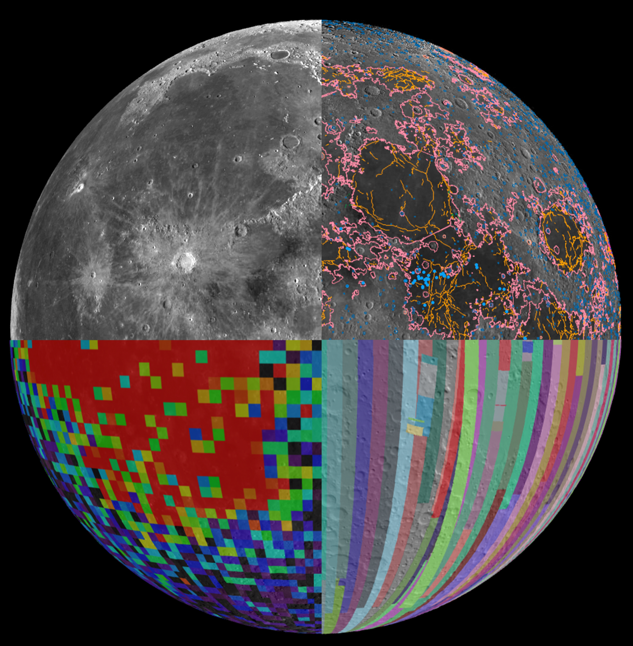
Lunar-FM integrates 18 distinct data layers from multiple orbital missions, including NASA’s Lunar Reconnaissance Orbiter (LRO), GRAIL, and Clementine, into a unified, multimodal architecture.
The model ingest includes optical imagery, topography (LOLA), thermal emissions (Diviner), radar reflectivity (Mini-RF), and gravity anomalies (GRAIL). Utilizing Vision Transformers, the model creates a unified, 768-dimensional latent embedding space that captures lunar properties up to 70 degrees north and south of the equator.
Key Technical Findings and Capabilities
Lunar-FM comes with several validated capabilities relevant to planetary science and in-situ resource utilization (ISRU):
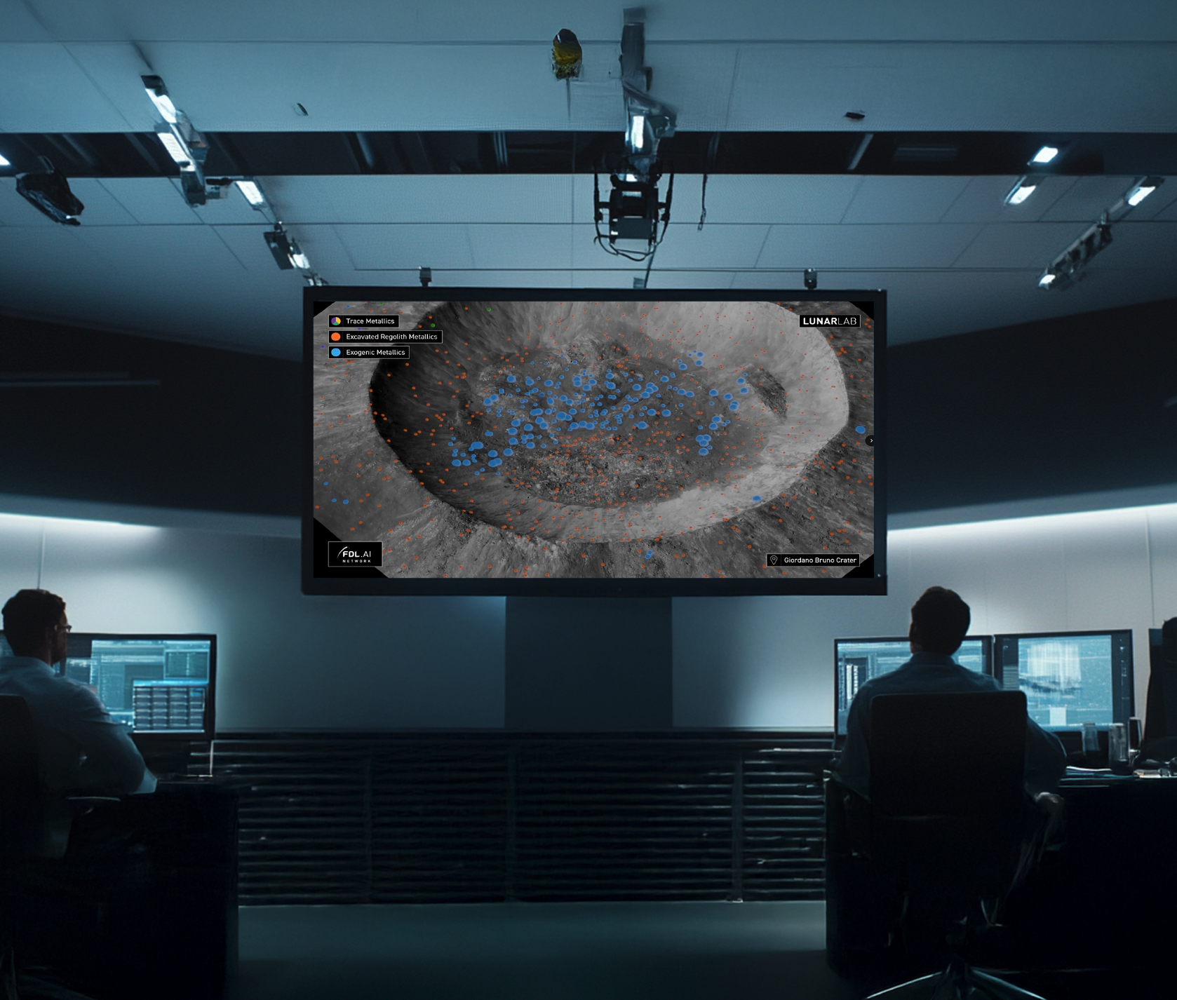
Few-Shot Learning of Lunar Resources: Validation tests demonstrated the model’s ability to generate high-fidelity global predictive maps of valuable resources from extremely scarce ground-truth data. In a case study regarding Titanium Dioxide (TiO2) abundance, the model produced a global map correlating with ground-truth using only eight expert-labeled samples from the Apollo landings.
Data Compression for use on PCs: The model achieves a 300x compression of the input data, condensing multi-modal instrument mosaics into a set of embeddings that allows complex scientific investigations to be run on standard computing infrastructure.
Filling Sensor Gaps and Similarity Search: Lunar-FM reconstructs missing data by learning correlations across modalities (e.g., predicting thermal properties based on topography and optical data), addressing gaps in sensor coverage. Users can easily identify other features of interest using similarity search.
Geologic Boundary Classification: Embeddings were validated against the USGS Unified Geologic Map of the Moon, demonstrating that the latent space encodes compositional and textural information aligning with human-defined geologic boundaries.
Lunar-FM Applications
The capabilities of Lunar-FM support a range of critical applications for science, resource utilization, and mission planning:
Identify High-Potential Resource Sites (e.g., ilmenite-rich basalts, FeO-rich regolith, KREEP terrains).
Locate and Characterize Polar Volatile Deposits, including mapping likely water-ice stability zones using thermal data (e.g., Diviner Nighttime Minimum Temperature).
Select Optimal Landing Sites by combining critical topographical and physical constraints: slope, surface roughness (e.g., RMS height), rock abundance, and illumination conditions.
Plan Safe and Energetically Efficient Rover Traverses using integrated topography, roughness, and thermal data (to predict potential component stress).
Model Thermal Environments for lander, rover, and habitat design, considering diurnal (day/night) cycles, cold traps (Permanently Shadowed Regions, or PSRs), and overall thermal stress on hardware.
Assess Regolith Mechanical Properties (grain size, compaction, blockiness) to support excavation and ISRUoperations.
Detect Subsurface Geological Structures (e.g., mascons, buried basins, intrusions) linked to mineral enrichment, primarily using gravity anomaly data (e.g., GRAIL Bouguer maps).
Differentiate Geological Units (e.g., mare vs. highlands, pyroclastics, fresh vs. mature surfaces) to refine exploration strategies and understand the Moon’s geological evolution.
Estimate Near-Surface Hydrogen Abundance (a proxy for water content) for water extraction feasibility studies, primarily using neutron spectrometer data (e.g., LEND).
Support Long-Term Infrastructure Planning, including site selection for power grids, communications relays, mobility corridors, and bulk storage facilities.

ISRU: In-Situ Resource Utilization—the practice of harvesting and using materials found.
KREEP: Rock or regolith components rich in K (Potassium), R(Rare Earth Elements), and P (Phosphorus). These terrains are of high interest for rare Earth element.
Mascons: Mass Concentrations—regions beneath the lunar surface with an excess of mass (high density), typically associated with buried impact basin floors.